At just six feet above sea level and sitting on the porous Miami Limestone formation, Hialeah’s 220,000 residents live atop one of the most dissolution-prone karst platforms in the United States. Every new warehouse expansion near the Palmetto Expressway or mid-rise along West 49th Street contends with an invisible subsurface riddled with cavities, pinnacles, and a water table barely a meter below the asphalt in the wet season. In our laboratory, we see the consequences of guessing wrong: differential settlement that cracks tilt-wall panels within the first year. That reality is what makes seismic tomography the first logical step before any deep foundation design. We run both refraction and reflection surveys to map the top-of-limestone surface and detect velocity anomalies that flag potential voids — data that a standard SPT simply cannot provide across a heterogeneous rockhead. When the IBC requires site-specific ground motion analysis under ASCE 7 Chapter 20, we pair these tomographic profiles with downhole shear-wave data to build a defensible Site Class model. The methodology is straightforward in principle: we lay out a 48- or 96-channel spread, strike a sledgehammer or drop an accelerated weight, and let the P-wave and S-wave arrivals tell us where the limestone is competent and where it has been hollowed out by decades of groundwater flow. For deeper targets beyond 100 feet, reflection processing picks up stratigraphic boundaries that refraction alone would miss. Our team has applied this on sites from Hialeah Gardens to the Amtrak station corridor, and the consistency of the Miami Limestone's seismic velocity — around 3,500 to 4,500 m/s when intact — gives us a reliable baseline against which low-velocity zones stand out immediately. If you are also dealing with shallow fill over the limestone, a complementary MASW survey can provide the shear-wave velocity profile needed for liquefaction screening in the upper 30 meters — a combination we recommend whenever the geotechnical baseline report calls for both stiffness and cavity detection.
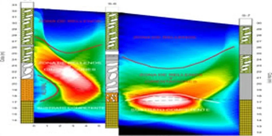
A velocity reversal in the Miami Limestone is the single clearest geophysical signature of a roofed cavity — and it is invisible to a standard boring log.
Scope of work in Hialeah
Typical technical challenges in Hialeah
In Hialeah, the most common error we observe is a geotechnical report that depends solely on SPT borings spaced 50 or 75 feet apart and presumes the limestone surface is a smooth, gradual transition. In a karst environment where pinnacles can rise 8 feet over a 20-foot horizontal distance and solution pipes extend 30 feet deep, this assumption is not merely incorrect—it is expensive. We have been summoned to sites where a driven pile encountered refusal 5 feet earlier than indicated by the boring, only to break through a thin crust into a mud-filled void two weeks later when the rig moved ten feet laterally. Seismic tomography fills that spatial void because it generates a continuous 2D cross-section rather than a point measurement every 6 to 12 inches like a split-spoon sample. According to ASCE 7-16 Section 20.3, a site with karst features can be classified as Site Class D or lower depending on the contrast between intact rock velocity and infill material velocity; misclassifying this shifts the design spectral accelerations up or down, impacting the entire structural cost. We also note that the high water table—less than 5 feet below grade in most of Hialeah year-round—dampens high-frequency seismic energy, so reflection surveys must be designed with smaller geophone intervals and a controlled-frequency source to maintain resolution beneath the water interface. Overlooking this detail yields reflection sections so unclear that no horizon can be reliably identified, a result we have witnessed from less experienced teams.
Our services
We organize seismic tomography projects in Hialeah into two service configurations that address the majority of commercial and infrastructure site investigation needs.
Refraction Tomography for Karst Mapping
A 2 to 4-line P-wave refraction survey processed with curved-ray tomography to map the limestone top, detect velocity reversals indicating cavities or solution features, and define the thickness of overlying fill. Includes ray-coverage density analysis so you know precisely which parts of the cross-section are well-constrained and which are interpolated. Typical line length: 100–150 meters per spread, targeting a depth of 25–35 meters below grade.
Combined Refraction & Reflection for Deep Targets
For sites requiring depth penetration exceeding 100 feet—such as deep pile foundations for Hialeah's larger commercial structures—we incorporate a high-resolution P-wave reflection component into the refraction spread. CMP processing and NMO correction yield reflectivity sections that image stratigraphic boundaries, paleochannels, and the contact between the Fort Thompson Formation and the underlying Tamiami Formation. This dual-method approach meets IBC requirements for site-specific seismic hazard analysis when Site Class D or E is suspected.
Common questions
What depth can seismic tomography realistically reach in Hialeah's limestone?
With a 120-meter refraction spread, we typically resolve velocities down to 25–30 meters in the Miami Limestone; the high velocity of intact rock actually aids penetration because ray paths curve upward less aggressively than in soft soils. For targets beyond 30 meters, we adopt reflection acquisition, which can image horizons at 60 to 100 meters depending on source energy and the water table's effect on frequency attenuation.
How do you distinguish a water-filled cavity from a mud-filled cavity on the tomogram?
Both appear as low-velocity zones, but water-filled cavities typically exhibit P-wave velocities between 1,400 and 1,600 m/s, while mud- or clay-filled voids drop closer to 800–1,200 m/s. We cross-reference the velocity with Poisson's ratio where S-wave data exist: a Poisson's ratio above 0.4 strongly indicates water saturation, while values near 0.3 suggest unconsolidated sediment infill. A test boring through the anomaly confirms the interpretation.
What does a seismic tomography survey cost for a typical Hialeah commercial lot?
For a standard 2-line refraction tomography survey on a 1- to 2-acre commercial lot in Hialeah—including mobilization, field acquisition with a 48- to 96-channel spread, tomographic inversion, and a signed report with interpreted cross-sections—the project typically costs between US$3,100 and US$5,870. The range depends on line length, number of spreads, and whether we add a reflection component for deeper targets.
Will a seismic survey work on a site with asphalt or concrete paving?
Yes, but we must mount geophones directly on the paved surface using a fast-setting gypsum or wax couplant, and the source energy couples differently—a sledgehammer on asphalt can produce a noisier, lower-frequency wavelet than on bare soil. We account for this in processing by applying a bandpass filter that removes the low-frequency traffic rumble typical around Hialeah's commercial corridors. The tomographic resolution is not compromised as long as the geophone coupling is consistent.