Hialeah’s expansion from a 1920s racetrack town into a dense residential and industrial core placed thousands of structures atop the Miami Limestone formation, but the near-surface section is far from uniform. Oolite facies, localized sand lenses, and solution-weathered cavities create abrupt stiffness contrasts that a standard boring log cannot resolve. Our team has run multi-channel surface wave lines from Amelia Earhart Park to the industrial yards near the canal, and we see VS100 shifting from 300 m/s to over 800 m/s within a 200-foot lateral step. That variability drives the need for a continuous VS30 profile rather than a single-point assumption, especially when the IBC requires a defensible Site Class for structural design loads. The liquefaction assessment often gets triggered when the limestone cap is thin and loose saturated sand appears below 15 feet, which happens more often than the regional geology maps suggest.
A VS30 shift from 360 to 520 m/s across a single Hialeah lot changes the seismic design category enough to add a full lateral system upgrade.
Scope of work in Hialeah
Typical technical challenges in Hialeah
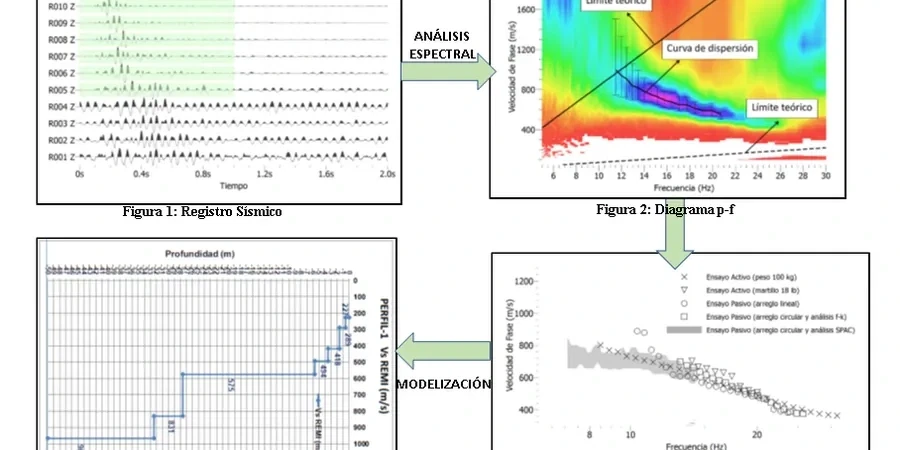
In Hialeah, a 24-channel Geode seismograph with 4.5 Hz vertical geophones spaced 2 meters apart is typically deployed in a straight line across the proposed structure's footprint; however, the city's compact light-industrial lots often necessitate a staggered or L-shaped array when a clear 46-meter line is unavailable. The primary field risk is coupling loss on the thin asphalt cap covering many warehouse districts: we drive geophone spikes through the pavement into the underlying soil, but a shallow limestone pinnacle can reflect energy and generate a stationary noise cone that obscures the Rayleigh wave. When this occurs, we transition to a passive roadside survey, recording 20 minutes of ambient traffic energy from Okeechobee Road or the Palmetto Expressway. The processed VS30 value directly feeds into the seismic base shear calculation per ASCE 7 Section 11.4.1; misclassifying Site D as Site C has led to at least two mid-rise projects in the county requiring a lateral system redesign after peer review flagged the discrepancy.
Our services
Geophysical testing in Hialeah must adapt survey geometry to the built environment, and deliverables need to be immediately usable by the structural engineer of record. Our service package encompasses the entire workflow from field layout to a stamped VS30 classification.
Active MASW for VS30 Site Class
We offer a 24-channel survey using a sledgehammer source, followed by dispersion analysis and 1D VS inversion, delivering the IBC Site Class letter required for permit submittal.
Passive Microtremor Array
A 20-30 minute ambient vibration recording leveraging traffic and wind energy, processed with SPAC or FK methods, resolves VS below 30 meters in deep soil or basin-edge settings.
Combined MASW + Seismic Refraction
Paired P-wave and S-wave profiling maps the top of limestone bedrock and computes Poisson's ratio for excavation rippability and settlement analysis.
VS30 Mapping for Multi-Building Sites
Grid or transect-based surveys over large commercial parcels produce contour maps of VS30 and Site Class boundaries for phased development planning.
Common questions
What does a MASW test in Hialeah typically cost for a single-family or small commercial lot?
For a standard active MASW line with passive extension and a stamped VS30 report, costs range from US$1,840 to US$2,740, depending on access constraints, number of lines, and the need for passive recording. Tight lots with asphalt cover requiring spiking and traffic control fall at the higher end.
How does Hialeah's limestone geology affect the shear wave velocity results?
The Miami Oolite can vary from highly cemented to almost unconsolidated over short distances. Vugs and solution features create low-velocity zones that a single boring may miss entirely; the continuous MASW profile captures the spatial average required by ASCE 7 for site classification, preventing mischaracterization of a mixed Site C/D profile.
Do you need both active and passive source data for a valid VS30 in Hialeah?
When the limestone contact is shallower than 15 meters, an active-source hammer survey alone may resolve 30 meters, but where sand or fill extends deeper, we run passive microtremor arrays to constrain the dispersion curve below 10 Hz. The passive component ensures the VS30 value is not biased by the limited low-frequency content of a sledgehammer source.
Can the MASW survey be done on an asphalt-paved lot without breaking the surface?
Yes, but it requires spiking geophones through the asphalt into the subgrade to achieve proper coupling. On thin pavement over soft soil, we can often plant directly; on thick concrete or reinforced slabs, we use a small hammer drill to create pilot holes for the geophone spikes, adding about an hour to field time.